-
자바 스프링 mysql 위치좌표(위도 경도) 정리, POINT DATAProject/NomadWorker 2022. 7. 22. 15:58
[한국외대 모각코] 도커 스터디 일정을 만든후 개인 공부를 한내용을 올린다.
다음 주 부터는 정기적으로 도커 내용이 TIL 에 들어 갈 듯 싶다.
내용 :자바 스프링 api 설계 주기능 : request 위도경도에 대한 response 로 주변 가게정보를 넘기는 api
Spring Boot
Spring jpa
mysql
자료 찾다보면 한번씩 하단 깃허브 와 관련된 블로그 자료를 볼것이다.
정말 감사함니다.. 대부분의 코드는 하단 깃헙을 참고하여 만들었습니다.
GitHub - wooody92/wooody92.github.io
Contribute to wooody92/wooody92.github.io development by creating an account on GitHub.
github.com
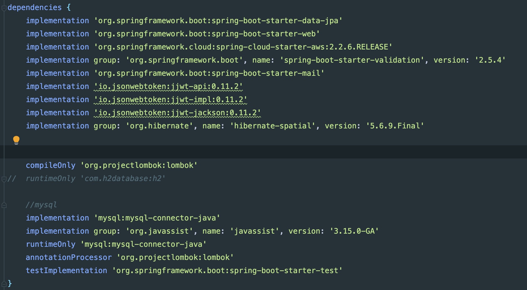
1. 버전확인 어쩌면 제일 중요한,,
mysql 크게 2 가지 버전이 있는데 v 5.6 과 v - 8이다 상황에 맞춰 gradle 이랑 yaml 을 맞춰 준다. 물론 hybernate 도..
1.application yml
jpa:
    hibernate:
      ddl-auto: update

    properties:
      hibernate:
        #show_sql: true
        format_sql: true
        default_batch_fetch_size: 100
        dialect: org.hibernate.spatial.dialect.mysql.MySQL8SpatialDialect
    database-platform: org.hibernate.spatial.dialect.mysql.MySQL8SpatialDialect
#    database-platform: org.hibernate.spatial.dialect.mysql.MySQL56InnoDBSpatialDialect
	database: mysql
2.build.gradle. 자신의 hibernate version에 맞게,,
implementation group: 'org.hibernate', name: 'hibernate-spatial', version: '5.6.9.Final'
2 . data 넣기
Java sping 에서 import org.locationtech.jts.geom.Point;
을 import 후 변수를 Point type 으로 지정 하면 mysql 에서는 POINT 타입이 아닌 GEOMETRY 로 들어간다.
생성한 point data 종류를 확인을 하자. 제발,,

상황 geometry 타입에 (50.8 4.44) 넣고 싶다.
다음 쿼리는 mysql workbench 에서 넣었다.
UPDATE `testdb`.`place` SET `p_gpoint` = ST_GeomFromText('POINT(50.8 4.44)') WHERE (`p_id` = '7');
binary 데이터로 들어간것을 볼수가 있다. 출력을 해보자 ! LineString 이란 사각형 범위를 만드는 것이라 생각하면 된다.
mysql 에서는 안보여서 터미널 에서 실행했다.
방금 넣은 좌표 (50.8 4.44 ) 가 범위에 들어 가도록 좌표 범위를 적어주고 , 범위에 맞는다면 맞는 p_weekt 를 출력하게 한다.
// 쿼리문,
SELECT p_weekt from  testdb.place AS p
	WHERE MBRContains(ST_LINESTRINGFROMTEXT('LineString(60.8 4.492860, 50.149710 4.335226)'), p.p_gpoint);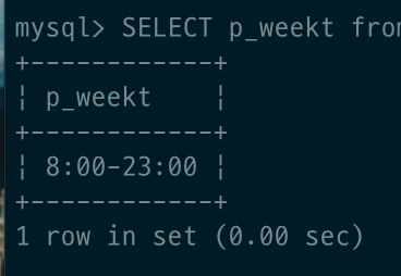
자 이제 ,, javasping,jpa 를 이용하자.
DOMAIN
package hackathon.nomadworker.domain;

import lombok.val;
import org.locationtech.jts.geom.Point;
import javax.persistence.*;
import lombok.Getter;
import lombok.Setter;

import java.util.ArrayList;
import java.util.List;


@Entity
@Getter
@Setter
public class Place {

        @Id @GeneratedValue
        @Column(name = "p_id")
        private long id;

        private String p_cate;

        private String p_name;

        private String p_weekt;

        private String p_weekndt;

        private String p_addr;

        private String p_image;

        private String p_storeType;

        private float p_latitude;
        private float p_longitude;

        private Integer rent_price;


        private Point p_gpoint;

        ...
}
Repository
package hackathon.nomadworker.repository;

import hackathon.nomadworker.domain.Place;
import hackathon.nomadworker.util.Direction;
import hackathon.nomadworker.util.GeometryUtil;
import hackathon.nomadworker.util.Location;
import lombok.RequiredArgsConstructor;
import org.springframework.stereotype.Repository;

import javax.persistence.Query;
import javax.persistence.EntityManager;
import javax.persistence.TypedQuery;
import java.util.List;

@Repository
@RequiredArgsConstructor
public class PlaceRepository {
    private final EntityManager em;

    ..
	..

    public List<Place> getNearByCoordinate(Double latitude, Double longitude, Double distance)
    {
        Location northEast = GeometryUtil
                .calculate(latitude, longitude, distance, Direction.NORTHEAST.getBearing());
        Location southWest = GeometryUtil
                .calculate(latitude, longitude, distance, Direction.SOUTHWEST.getBearing());

        double x1 = northEast.getLatitude();
        double y1 = northEast.getLongitude();
        double x2 = southWest.getLatitude();
        double y2 = southWest.getLongitude();

        System.out.println(x1);
        System.out.println(y1);
        System.out.println(x2);
        System.out.println(y2);

        String pointFormat = String.format("'LINESTRING(%f %f, %f %f)')", x1, y1, x2, y2);
        System.out.println(pointFormat);
//         Query query = em.createNativeQuery("SELECT p.p_id, p.p_cate, p.p_name,p.p_addr, p.p_image \n" +
//                                                    "FROM  place AS p \n"+
//                                                    "WHERE MBRContains(ST_LINESTRINGFROMTEXT(" + pointFormat + ", p.p_point)",Place.class).setMaxResults(15);

        Query query = em.createNativeQuery("SELECT * \n" +
                "FROM  place AS p \n"+
                "WHERE MBRContains(ST_LINESTRINGFROMTEXT(" + pointFormat + ",p.p_gpoint)",Place.class).setMaxResults(15);


        List<Place> places = query.getResultList();
        System.out.println(places);
        return places;
    }


}
Repo 단에서 원하는것만 가져올려고 하다가 에러 나서 전체를 * 가져 온후 서비스 단에서 원하는 정보만 걸러준다
Utils 총 3 가지의 class
package hackathon.nomadworker.util;

import lombok.Getter;

@Getter
public enum Direction {
    NORTH(0.0),
    WEST(270.0),
    SOUTH(180.0),
    EAST(90.0),
    NORTHWEST(315.0),
    SOUTHWEST(225.0),
    SOUTHEAST(135.0),
    NORTHEAST(45.0);

    private final Double bearing;

    Direction(Double bearing) {
        this.bearing = bearing;
    }
package hackathon.nomadworker.util; public class GeometryUtil { public static Location calculate(Double baseLatitude, Double baseLongitude, Double distance, Double bearing) { Double radianLatitude = toRadian(baseLatitude); Double radianLongitude = toRadian(baseLongitude); Double radianAngle = toRadian(bearing); Double distanceRadius = distance / 6371.01; Double latitude = Math.asin(sin(radianLatitude) * cos(distanceRadius) + cos(radianLatitude) * sin(distanceRadius) * cos(radianAngle)); Double longitude = radianLongitude + Math.atan2(sin(radianAngle) * sin(distanceRadius) * cos(radianLatitude), cos(distanceRadius) - sin(radianLatitude) * sin(latitude)); longitude = normalizeLongitude(longitude); return new Location(toDegree(latitude), toDegree(longitude)); } private static Double toRadian(Double coordinate) { return coordinate * Math.PI / 180.0; } private static Double toDegree(Double coordinate) { return coordinate * 180.0 / Math.PI; } private static Double sin(Double coordinate) { return Math.sin(coordinate); } private static Double cos(Double coordinate) { return Math.cos(coordinate); } private static Double normalizeLongitude(Double longitude) { return (longitude + 540) % 360 - 180; } }package hackathon.nomadworker.util; import lombok.Getter; @Getter public class Location { private Double latitude; private Double longitude; public Location(Double latitude, Double longitude) { this.latitude = latitude; this.longitude = longitude; } }DTO. api requset, response 를 지정.
package hackathon.nomadworker.dto;


import hackathon.nomadworker.domain.Place;

import lombok.AllArgsConstructor;
import lombok.Data;
import org.locationtech.jts.geom.Point;

public class PlaceDtos
{
    @Data
    @AllArgsConstructor
    public static class PlaceResultResponse<T>
    {
    private String message;
    private int status;
    private T data;
    }

...
    @Data
    public static class PlaceDtoCoordinate
    {
        private long p_id;

        private String p_cate;
        private String p_name;
        private String p_image;

        public PlaceDtoCoordinate(Place place)
        {
            this.p_id = place.getId();
            this.p_cate = place.getP_cate();
            this.p_name = place.getP_name();
            this.p_image = place.getP_image();
        }
    }


...

}
Service
package hackathon.nomadworker.service;

import hackathon.nomadworker.domain.Place;
import hackathon.nomadworker.repository.PlaceRepository;
import lombok.AllArgsConstructor;
import org.springframework.stereotype.Service;

import java.util.List;
@Service
@AllArgsConstructor
public class PlaceService {
    private final PlaceRepository placeRepository;
    public List<Place> findPlacesByCategory(String place_tag) {return placeRepository.findPlacesByCategory(place_tag);
    }


    public List<Place> findPlacesByCoordinate(float latitude,float longitude)
    {   // 반견 1km
        return placeRepository.getNearByCoordinate((double)latitude, (double)longitude,(double)1);
    }

    public List<Place> findPlacesall()
    {
        return  placeRepository.findAll();
    }
}
API--
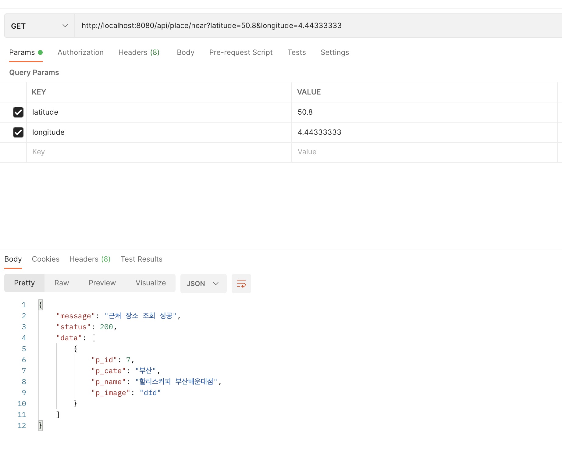
package hackathon.nomadworker.api;

import hackathon.nomadworker.domain.Place;
import hackathon.nomadworker.dto.PlaceDtos.*;
import hackathon.nomadworker.service.PlaceService;
import lombok.RequiredArgsConstructor;

import org.springframework.web.bind.annotation.GetMapping;
import org.springframework.web.bind.annotation.RequestHeader;
import org.springframework.web.bind.annotation.RequestParam;
import org.springframework.web.bind.annotation.RestController;
import java.util.stream.Collectors;

import java.util.List;

@RestController
@RequiredArgsConstructor
public class PlaceApiController {

    private final PlaceService placeService;


@GetMapping(value = "/api/place/near", produces = "application/json;charset=UTF-8")
    public PlaceResultResponse placeByCoordinateGet(@RequestHeader("Authorization") String u_uid,
                                                    @RequestParam("latitude") float latitude,
                                                    @RequestParam("longitude") float longitude) {
        List<Place> places = placeService.findPlacesByCoordinate(latitude,longitude);
        if (places.isEmpty()) {
            return new PlaceResultResponse("근처 장소 조회 실패", 400, null);
        } else {
            List<PlaceDtoCoordinate> collect = places.stream().map(place -> new PlaceDtoCoordinate(place)).collect(Collectors.toList());
            return new PlaceResultResponse("근처 장소 조회 성공", 200, collect);
        }
    }


}
결과.
(50.8 4.44) 을 넣었던 것이 근처 범위로 잘 나온다.
'Project > NomadWorker' 카테고리의 다른 글
Jsoup 웹 크롤링 , 스프링 부트 구글 지도 위도 경도 가져오기 (0) 2022.08.11